
 Amari
Amari (ἀμάρη): the irrigation conduit in Homer's Iliad.
Water distribution and irrigation networks
Design and hydraulic analysis of water distribution and irrigation networks — pipes, pumps, valves, tanks and reservoirs, with the demands that load them — from the survey to the drawings and the bill of quantities, on EPA EPANET.
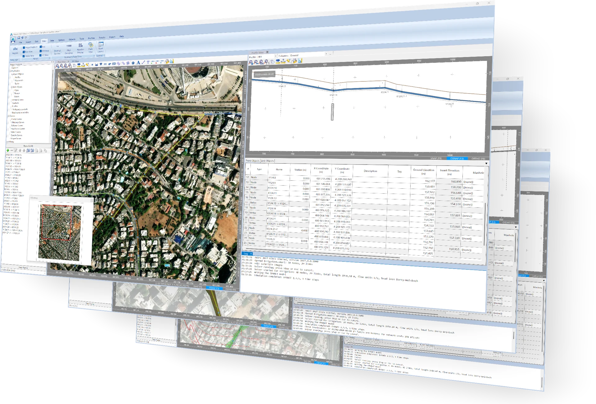
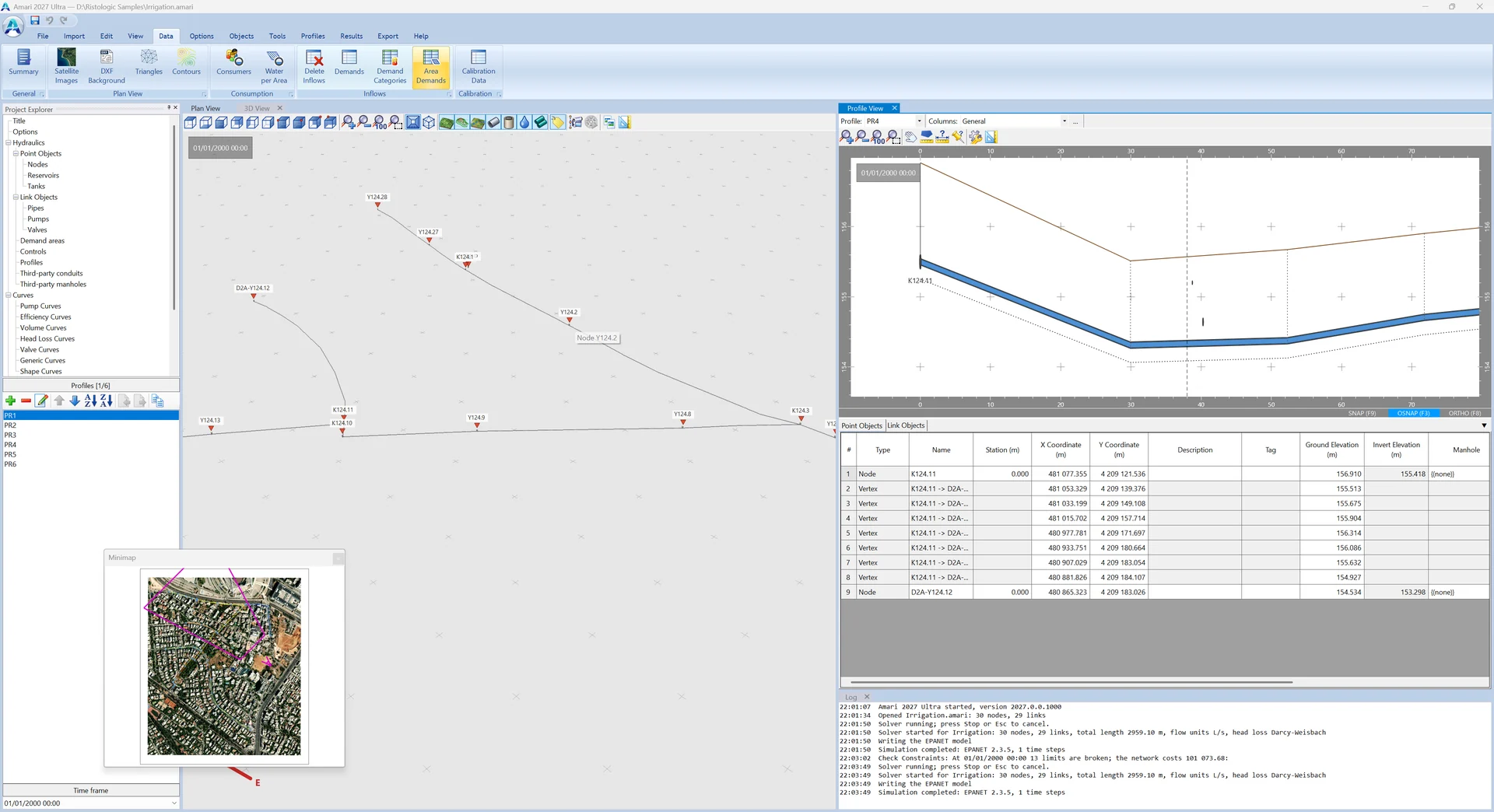
Amari is a Windows program for the design and the hydraulic analysis of water distribution and irrigation networks: pipes, pumps, valves, tanks and reservoirs, with the demands that load them and the water quality that travels with them. It shares Rheon's way of working — one model from the survey to the drawings and the bill of quantities.
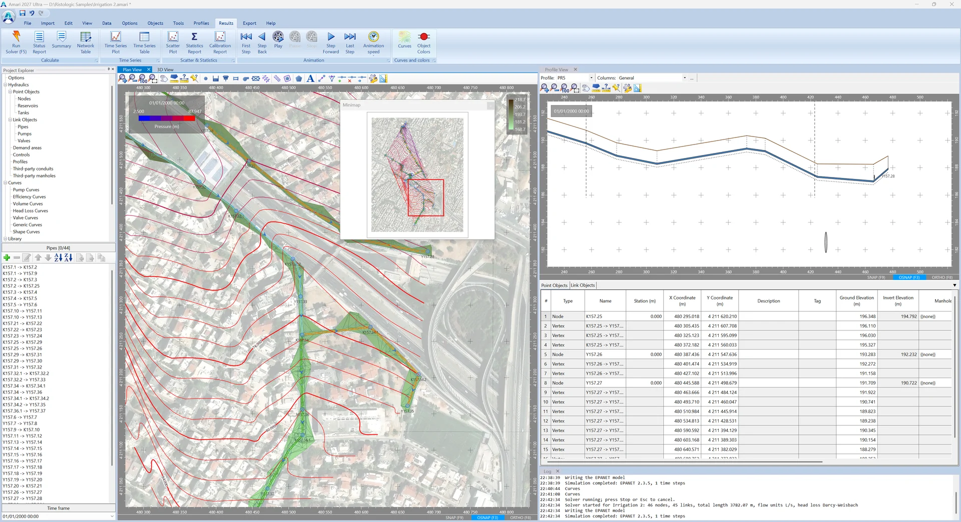
The hydraulics are solved by EPANET 2.3, the reference model for pressurised water networks, in extended period: heads, pressures, flows and velocities at every time step, the controls and rules of pumps and valves, and the water quality.
What Amari does
Demands
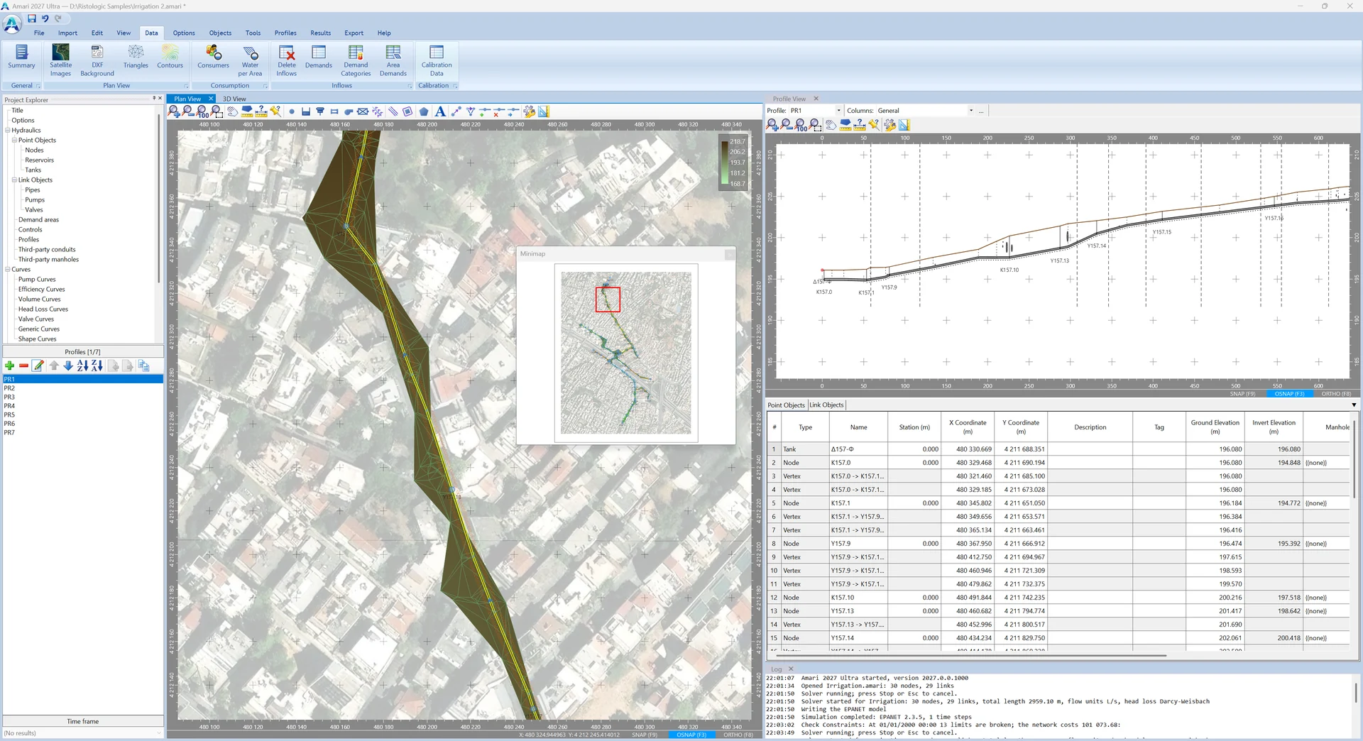
Population with its design period, consumers and demand categories, water per area and demand areas drawn or read from DXF, distributed to the nodes.
Hydraulic checks
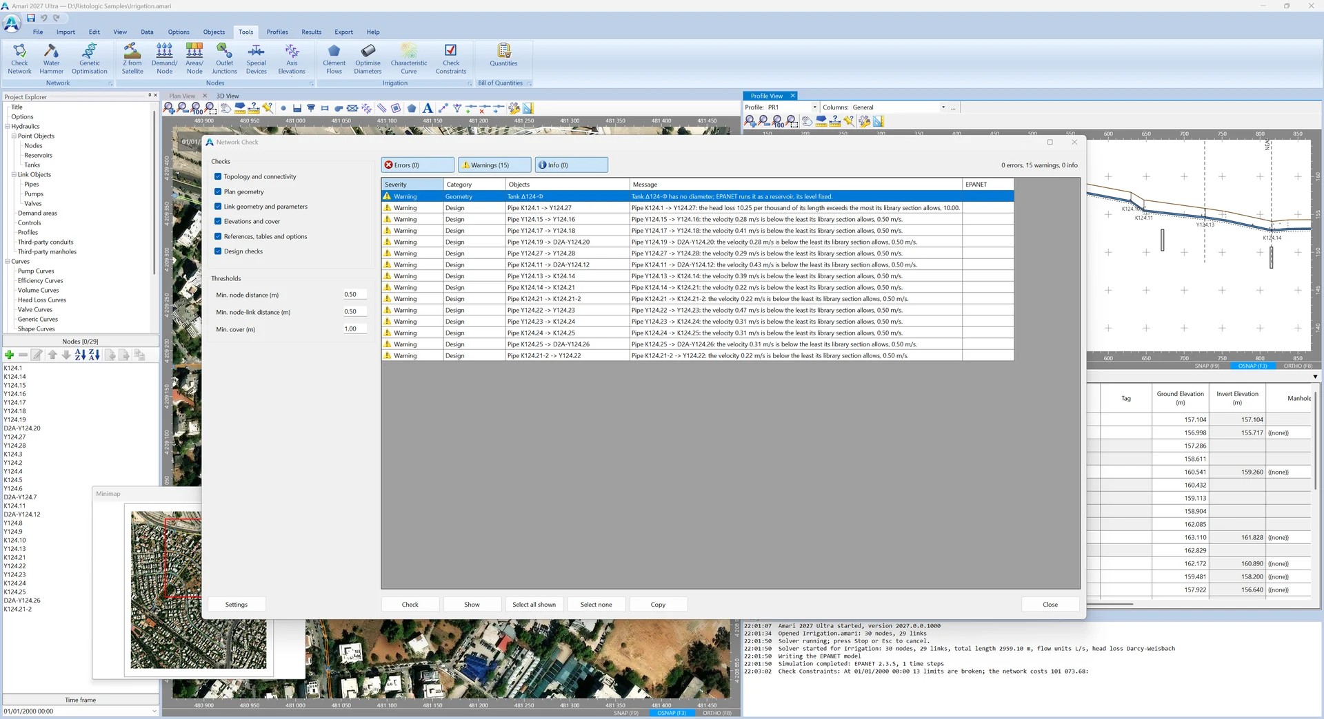
Velocity, pressure and head loss per kilometre against the limits of each pipe section and node, with the failing objects named and shown on the plan.
Water hammer Pro
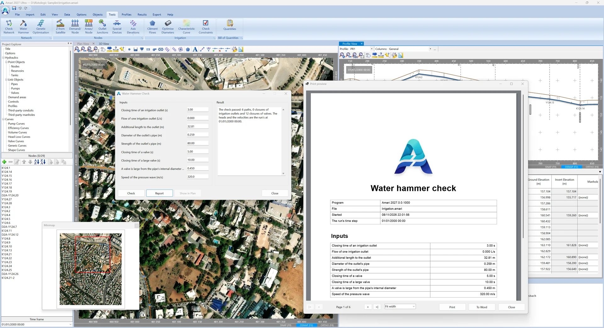
The irrigation network checked against the water hammer of an outlet's or a valve's closure, path by path, with the heads and the velocities of the run.
Irrigation Pro
Clément's flows for on-demand irrigation, the least-cost diameters within the pressure limits by linear programming, the network's characteristic curve with the pumping station in present value, and the check of the constraints.
Optimisation and calibration Pro
A genetic optimisation of the pipe sizes against their cost; the calibration of the model to field measurements, with its report and the measurements on the graphs.
Drawings and reports
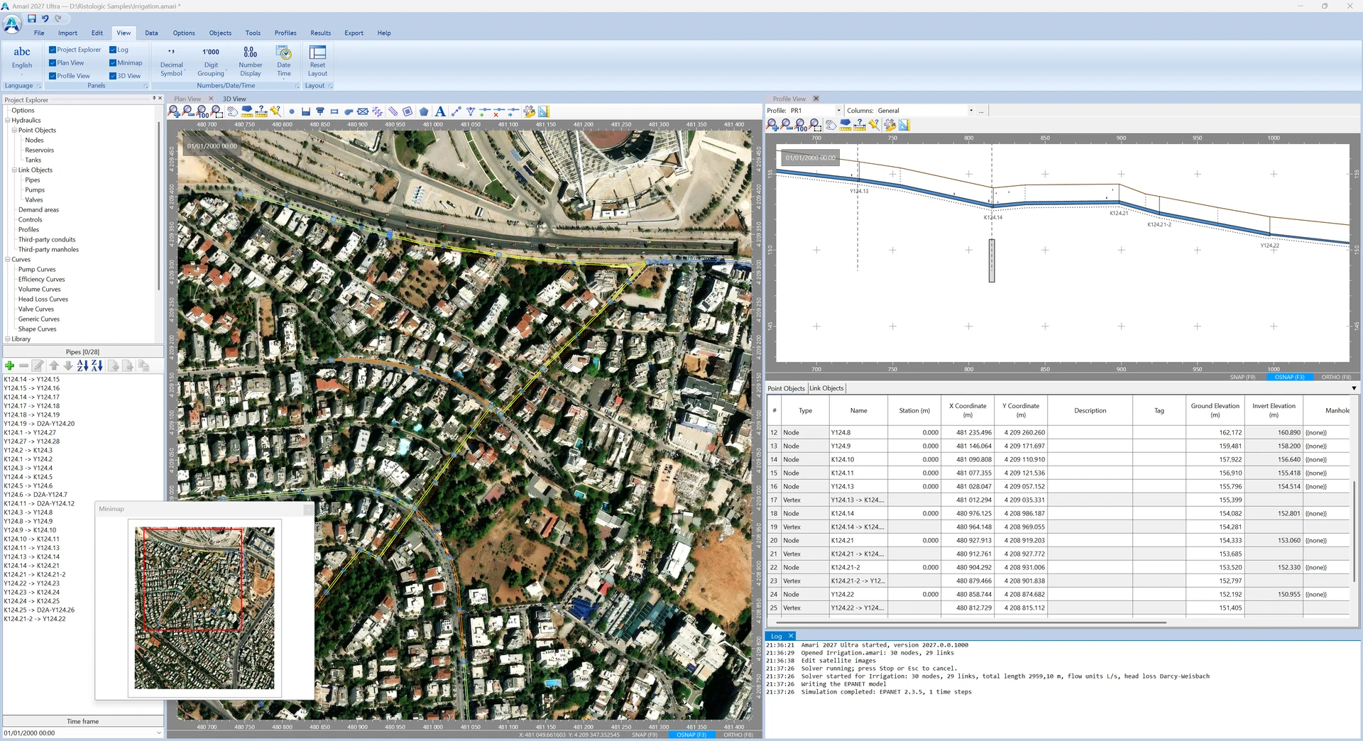
Plan and profiles with the hydraulic grade line as DXF, a multithreaded 3D view of the network on the terrain, movies of the run on the plan, the profiles and the 3D view and flights over it, satellite imagery and elevations from the web; the report as a Word document and the results as an Excel workbook, without Microsoft Office.
Bill of quantities Pro
Excavation, bedding, backfill and surface restoration by each pipe's trench, with the network's fittings — the air valves and washouts among them.
Data exchange
EPANET input files both ways, with the choice of what to read; EPANET scenarios and map files; shapefiles, GPX, KML and LandXML; networks and demand areas from DXF; Rheon's sewers as a third-party network.
An AI assistant beside you Pro
Claude, or any MCP client, can work on the open project with your consent — every change in front of you, and every change undoable.
Amari editions compared
Every capability, edition by edition — the same table as the manual's. Demo opens and explores projects; Lite is the full program for most offices; Pro adds the advanced tools.
| Capability | Demo | Lite | Pro |
|---|---|---|---|
| Projects and files | |||
| Opening projects (.amari) and the sample projects | ✓ | ✓ | ✓ |
| Saving projects (.amari) | ✗ | ✓ | ✓ |
| Inserting another Amari project's objects into the current one | ✗ | ✓ | ✓ |
| Inserting another Amari project, or a Rheon project, as a third-party network, to check for conflicts | ✗ | ✗ | ✓ |
| Undo and redo of every step, the log of actions | ✓ | ✓ | ✓ |
| Printed report of the data and the results, with its print preview | ✓ | ✓ | ✓ |
| Import | |||
| EPANET .inp files, with the choice of the sections to read | ✗ | ✓ | ✓ |
| EPANET scenarios (.scn) | ✗ | ✓ | ✓ |
| EPANET map files (.map) | ✗ | ✓ | ✓ |
| DXF: the background drawing, contours and triangles | ✓ | ✓ | ✓ |
| DXF: the network and the demand areas | ✓ | ✓ | ✓ |
| LandXML terrain surfaces (TIN) | ✓ | ✓ | ✓ |
| A pipe route from SHP, GPX or KML/KMZ | ✓ | ✓ | ✓ |
| Junctions, reservoirs, tanks, pumps and valves from point shapefiles | ✓ | ✓ | ✓ |
| Library entries | ✓ | ✓ | ✓ |
| Export | |||
| Word: the whole data-and-results report | ✗ | ✓ | ✓ |
| Excel: the options, and the nodes and links at every reporting time | ✗ | ✓ | ✓ |
| DXF: the plan view | ✗ | ✓ | ✓ |
| DXF: the profiles, with the hydraulic grade line | ✗ | ✓ | ✓ |
| EPANET .inp files | ✗ | ✓ | ✓ |
| EPANET scenarios (.scn) | ✗ | ✓ | ✓ |
| LandXML: the network as a pipe network | ✗ | ✓ | ✓ |
| SHP, GPX and KML: the pipe route and the plan view | ✗ | ✓ | ✓ |
| Movie of the plan, profile or 3D view, and of a flight over the 3D view | ✗ | ✓ | ✓ |
| Library entries | ✗ | ✓ | ✓ |
| Plan view and objects | |||
| Junctions, reservoirs and tanks | ✓ | ✓ | ✓ |
| Pipes, pumps and valves | ✓ | ✓ | ✓ |
| Demand areas, map labels and profiles | ✓ | ✓ | ✓ |
| Patterns, curves, simple controls and rules | ✓ | ✓ | ✓ |
| Drawing with snaps and exact point input, intermediate vertices of links | ✓ | ✓ | ✓ |
| Layers: satellite images, background drawing, contours and triangulated surface | ✓ | ✓ | ✓ |
| Project explorer, object properties, find, query and selection sets | ✓ | ✓ | ✓ |
| Libraries: pipes, manholes and trenches | ✓ | ✓ | ✓ |
| Renaming, node alignment, conversion of nodes and links, change of direction | ✓ | ✓ | ✓ |
| Minimap | ✓ | ✓ | ✓ |
| 3D view: the network on the terrain, the satellite drape, flights along a profile | ✓ | ✓ | ✓ |
| Third-party networks: drawing and display on the plan and the profiles, their conflicts with the network | ✗ | ✗ | ✓ |
| Profiles | |||
| Profile view with its grid of nodes and links, and the hydraulic grade line of the run | ✓ | ✓ | ✓ |
| Pipe crossings, road crossings and special devices on a profile | ✓ | ✓ | ✓ |
| Renumbering the nodes of a profile | ✓ | ✓ | ✓ |
| Demands | |||
| Base demands and patterns of the junctions, demand categories | ✓ | ✓ | ✓ |
| Consumers: consumption, peak factors and design flows | ✓ | ✓ | ✓ |
| Population projected to the design period | ✓ | ✓ | ✓ |
| Water per area: the nodes' area demands and the demand areas | ✓ | ✓ | ✓ |
| Hydraulics and results | |||
| The EPANET engine: extended period, every head-loss formula, pumps, seven kinds of valve, tanks, emitters, controls and rules, energy and cost | ✓ | ✓ | ✓ |
| Water quality: a chemical with its reactions, the age of the water, a trace from a node | ✓ | ✓ | ✓ |
| Check Network | ✓ | ✓ | ✓ |
| Hydraulic checks: velocities, pressures, head loss per kilometre | ✓ | ✓ | ✓ |
| Results: status report, energy and reactions, network table, time series, scatter plots, statistics | ✓ | ✓ | ✓ |
| Animation of the results on the plan and the profile | ✓ | ✓ | ✓ |
| Result curves and object colours by result | ✗ | ✗ | ✓ |
| Tools ▸ Nodes | |||
| Ground elevations from a web service, the TIN, contours, a terrain file or the Copernicus DEM | ✗ | ✗ | ✓ |
| A total demand split over pipes by their length | ✗ | ✗ | ✓ |
| A total area split over pipes by their length, as area demands | ✗ | ✗ | ✓ |
| Outlet junctions of demand areas, the nearest to their centroid | ✗ | ✗ | ✓ |
| Air valves at the high points and washouts at the low points | ✗ | ✗ | ✓ |
| Axis elevations: a depth below the ground, all automatic or all typed | ✗ | ✗ | ✓ |
| Tools ▸ Network | |||
| Water hammer of an outlet's or a valve's closure, path by path | ✗ | ✗ | ✓ |
| Genetic optimisation: the least-cost library entries for any network | ✗ | ✗ | ✓ |
| Tools ▸ Irrigation | |||
| Clément's flows of the irrigation outlets | ✗ | ✗ | ✓ |
| Optimum diameters by linear programming, within the pressure limits | ✗ | ✗ | ✓ |
| Characteristic curve: the least cost against the source's head, with the pumping station in present value | ✗ | ✗ | ✓ |
| Check of the pressures, the velocities and the cost against the limits | ✗ | ✗ | ✓ |
| Calibration and quantities | |||
| Calibration data and report: measured demands, heads, pressures, qualities, flows and velocities against the run | ✗ | ✗ | ✓ |
| Bill of quantities: excavation, bedding, backfill and surface restoration by the trench, and the network's fittings | ✗ | ✗ | ✓ |
| AI connection | |||
| An AI assistant (Claude or any MCP client) working on the open project beside you, with your consent, through the window's own commands, with pictures of the plan and the panels | ✗ | ✗ | ✓ |
| Interface and support | |||
| Interface in English, Greek, German, French and Spanish | ✓ | ✓ | ✓ |
| The manual in English, Greek, German, French and Spanish, F1 help in every window, EPA's EPANET manual | ✓ | ✓ | ✓ |
| Number display: decimals, decimal symbol, digit grouping | ✓ | ✓ | ✓ |
| Report a problem, check for updates | ✓ | ✓ | ✓ |
System requirements
- Operating system
- Windows 10 or 11, 64-bit
- Engine
- EPANET 2.3
- Languages of the program
- Ελληνικά · English · Deutsch · Français · Español
- Manual
- Greek, English, German, French and Spanish (PDF and HTML help)
- Microsoft Office
- Not needed for the Word and Excel output
- Support
- support (at) ristologic.com
See it on your own projects
Ask for a quote or for the demo edition.